Ground truth for outdoor datasets
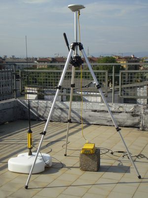
As already explained here, outdoor datasets from Rawseeds include two kinds of ground truth: executive drawings and robot trajectory. To reconstruct the trajectory of the robot through the explored environment, we used a high precision RTK (Real Time Kinematics) GPS system. Rawseeds’ RTK-GPS setup was composed of:
- a Trimble 5700 GPS receiver with Zephyr GPS antenna, mounted on the mobile robot (rover);
- a Trimble MS750 receiver with Zephyr antenna, mounted in a fixed location (base station);
- a Trimble PDL450 radiomodem, to transmit positioning information from the base station to the rover.
This system has – in best conditions of satellite signal reception – a positioning precision of 1cm horizontal and 2cm vertical. In all the locations where data acquisition occurred, the base station has been set in elevated points to maximize satellite visibility, i.e. on the top of tall buildings with no obstructions in their vicinity.
In actual use, satellite visibility has never been a problem for the base station, while it proved to be extremely critical for the rover. The presence of buildings, structures or even trees in the vicinity of the rover heavily disturbed the reception of satellite signals. Despite careful setup and planning of the acquisition sessions with reference to the visibility of satellite constellations (which evolve quickly through the day, and change slowly from day to day), RTK-GPS technology in urban settings proved to suitable for Rawseeds’ requirements, but very critical and sensible to setup issues. Even in quite sparse urban environments, such as the Polimi-Durando location, the best positioning quality (corresponding to the so-called RTK fixed integers mode of operation) was available only on limited parts of the robot’s trajectory. This was expected, but we hoped for a wider tolerance. Lower-grade positioning precisions (within a few centimeters of error, so still compliant with Rawseeds’ specifications) were available through significant parts of the robot’s path: therefore it has been possible for Rawseeds to gather good ground truth data in outdoor environments. However, our experience showed that RTK-GPS technology is too costly and prone to setup and reception issues to be considered as a not-auxiliary sensor in robotics applications.
A quantitative analysis of the ground truth data provided by the RTK-GPS system of Rawseeds is available in Deliverable AD2.3.
